Construction Goes Digital – The Road Ahead for the AEC Industry. The AEC industry is rapidly moving towards a completely digitalized project delivery process. Manual site surveys, 2D drawings, and a disconnected, fragmented set of project information that arrives too late at the wrong people on the project team are no longer sufficient for the ever-increasing complexity of buildings and civil engineering works, which are also being delivered under extreme time pressure and at high cost.
This Guide to advanced construction workflows explores how a combination of Reality Capture, Scan to BIM, BIM, and associated applications, such as 4D scheduling and 5D cost management, can be used to create and use a fully accurate and complete digital representation of physical assets and the processes to develop such a model to increase collaboration between stakeholders and to reduce rework and improve decision-making at all stages of the construction project.
This guide will examine in greater detail how advanced construction workflows are changing the way projects are delivered. We will look at how surveying on site is used to create a Reality Capture or Scan to BIM model and then follow the project through to its completion. We will look at how 4D scheduling and 5D cost management are used in conjunction with the BIM model to create a collaborative project environment.
Why Construction Needs Advanced Digital Workflows
The AEC industry has grown exponentially, with construction projects of ever-increasing complexity. The average commercial building today is made up of thousands of individual components that must be brought together by multiple different disciplines. The traditional way of managing information from the various project team members is not sufficient to manage the complexity of today’s construction projects.
Construction has traditionally found it difficult to manage an increase in complexity when delivering building projects since information is often stored on different platforms and teams work in isolation to deliver their part of the project. Additionally, design changes are very time-consuming and labor-intensive for all involved within the project.
Usual challenges include:
- Inaccurate site surveys
- Design clashes discovered during construction
- Manual quantity takeoffs
- Schedule delays
- Budget overruns
- Rework due to outdated information
- Limited collaboration between stakeholders
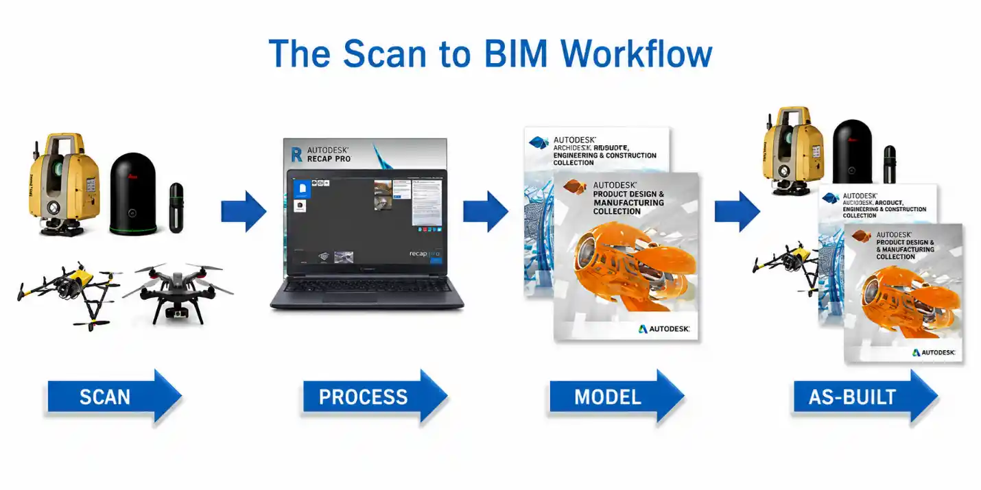
Digital Construction Workflows Integrating Reality Capturing
What Are Advanced Construction Workflows?
For a long time, surveying, design, planning, construction, and operation of a building were topics that were treated in separate isolation. However, there are now advanced digital workflows for designing and managing construction projects in an integrated and data-driven manner.
A typical workflow includes:
- Reality Capture
- Point Cloud Processing
- Scan to BIM Modeling
- BIM Coordination
- Clash Detection
- 4D Construction Planning
- 5D Cost Estimation
- Construction Monitoring
- Digital Twin & Facility Management
Understanding Advanced Construction Workflows
Advanced construction workflows support a streamlined process from site survey, through design and planning, to the construction phase and the later post-construction facility management. The various processes of surveying, design, planning, and the actual construction of a building are, in traditional projects, not combined.
At the core of these ‘new’ processes are a set of digital tools, which are introduced in to every phase of the Construction process to create an integrated project delivery model by linking up all of the established business processes to create an integrated, collaborative and connected project information environment, where information from all of the contributing phases are stored, and continuously updated throughout the entire project lifecycle.
BIM is used as a central data repository that is constantly updated through the various stages of a project. The integrated construction work process simplifies project execution in equal measure. At the end of the construction period, a Digital Twin is created, enabling better facility management than would otherwise be the case.

From Scan to BIM to Digital Workflows
Typical Advanced Construction Workflow
As all projects are different, the processes and workflows for a digital construction project can differ from project to project. However, most processes will follow a structured sequence.
- Reality Capture of the existing site
- Point Cloud Processing
- Scan to BIM Modeling
- Design Development
- BIM Coordination
- Clash Detection
- Construction Planning
- 4D BIM Scheduling
- 5D BIM Cost Management
- Construction Monitoring
- As-Built Documentation
- Digital Twin & Facility Operations
Why Traditional Construction Workflows Fall Short
Even though manual site surveys, 2D drawings, and independent documentation of the various project components have proven to be effective in the past for managing construction projects, the traditional methods of project management are no longer able to keep up with the fast-changing face of construction.
Common problems in building projects using the traditional methods and workflows are:
- Inaccurate or incomplete site surveys
- Design clashes found during construction
- Manual quantity takeoffs
- Lengthy approval processes
- Communication gaps between stakeholders
- Frequent rework due to outdated drawings
- Difficulty tracking design revisions.
- Higher project risks and cost overruns
Reality Capture: The Foundation of Modern Construction Workflows
Reality Capture, also known as ‘as-built’ or ‘as-is’ scanning, is a process of documenting real-world objects or environments with precise information using the latest surveying technologies like laser scanners, drones, mobile mapping, and 360-degree cameras. The process of Reality Capture involves collecting a huge amount of precise data in the form of points or millions of dimensions of the physical environment. The data collected can be used to create a correct and detailed information model of the existing environment, for use by architects, designers and designers, and building contractors alike to develop designs based on correct information for development. Reality Capture is now an integral part of modern construction workflows, as it helps to minimize uncertainty at the beginning of a project before design work begins.
The global Reality Capture market was valued at $6.8 billion in 2025 and is projected to reach $18.9 billion by 2034, with a 14.2% CAGR, driven by the construction sector. Reality Capture Software specifically is growing even faster from $3.8 billion in 2025 to $11.2 billion by 2034 (12.7% CAGR) as BIM mandates in North America, Europe and Asia-Pacific make scan-based as-built documentation a project prerequisite rather than an option.
Why Reality Capture Matters
The data that is gathered during the Reality Capture process will affect the rest of the project. Thus, every inaccuracy that is introduced into the surveying process will lead to severe problems in later project stages. The extensive information gathered on a site’s current state at the project’s onset can be of major help to project teams in:
- Reduce design assumptions.
- Minimize costly site visits.
- Improve design accuracy.
- Enhance multidisciplinary coordination.
- Support renovation and retrofit projects.
- Create reliable as-built documentation.
- Monitor construction progress over time.

Point Cloud Mapping
Technologies Used Capture
In hybrid Reality Capture, several technologies are combined for a project. Depending on the aims, accuracy, and site situation, several methods are used.
Laser Scanning (LiDAR)
Laser Scanning (LiDAR) – Laser scanning, commonly known as LiDAR (Light Detection and Ranging), is one of the most correct methods of capturing three-dimensional spatial data. All points measured by the laser scanner are then used to create a correct digital model of the environment the scanner has surveyed. This 3D model can then be used for a variety of different applications.
A terrestrial laser scanner is used to pick up details of structural elements, mechanical equipment, pipework, electrical systems, and building façades. A detailed pick-up of the interior spaces is also achieved. Many Reality Capture projects also involve the scanning of an industrial plant.
Drone Photogrammetry
The use of a building laser scanner for surveying a building and its interior spaces is, in most cases, far more efficient than a conventional survey. The drone, on the other hand, is used for surveying the larger outdoor area of a building or a site in detail.
Aerial photos are taken from high altitude with a high-quality camera. These photos are taken from many different angles, and after processing by specialized software, the images are used to create 3D models, orthophotos, and even terrain maps.
This technology is particularly valuable for:
- Infrastructure projects
- Highway construction
- Large commercial developments
- Earthwork calculations
- Topographic surveys
- Mining operations
- Site progress monitoring
Mobile Mapping Systems
Mobile Mapping Systems are offered as a combination of LiDAR scanners, cameras, GPS receivers, and Inertial Measurement Systems, which are mounted on vehicles or are even handheld and moved from place to place. In contrast to static laser scanners, the Mobile Mapping System offers the possibility to gather spatial information while in motion. This technology is in stark contrast to conventional photographic surveying.
Common applications include:
- Roads and highways
- Rail networks
- Utility corridors
- Airports
- Large industrial plants
- Urban infrastructure
360-Degree Imaging
360- degree cameras record site information in the form of images that ease site information for the design team, contractor, and facility’s owner and manager.
Panoramic images (from 360-degree cameras) taken on site can be integrated with the BIM model. This means designers, building contractors, and building owners can revisit a site that has already been completed (virtually) in the greatest detail without returning to the site.
These images are widely used for:
- Site documentation
- Progress tracking
- Remote inspections
- Quality assurance
- Stakeholder communication
Scan to BIM: Converting Reality into Intelligence
The term Scan to BIM is used to describe the process of converting point cloud data into an intelligent Building Information Model (BIM) using the point cloud as a reference to create the parametric objects that represent the individual building elements, such as walls, columns, beams, doors, and windows, as well as ductwork, pipes, and equipment, etc., of the existing building.
In contrast to simple 3D models, the BIM elements, created based on the point cloud, have relevant data to support decisions throughout the entire project life cycle.
Why Scan to BIM Is More Than 3D Modeling?
There is a prevalent misconception in the AEC industry that creating a BIM from a point cloud is equivalent to manually drawing out all the objects from the scanned data. This is clearly a time-consuming and cost-prohibitive endeavor and is one of the reasons why many have not adopted a BIM from point cloud approach. Instead, automatically creating a data-rich 3D model from a point cloud that includes more than just the physical dimensions of building elements is what Scan to BIM is all about.
Autodesk’s ReCap Pro 2026 now ships with a fully native scan-to-mesh pipeline, no additional licences or third-party tooling required, which, alongside AI-driven point cloud classification, is compressing Scan to BIM project timelines by up to 70% compared with 2023 benchmarks. This directly closes the historical productivity gap that made Scan to BIM commercially borderline on smaller retrofit projects.
For example, a wall in BIM could hold the following data:
- Material specifications
- Fire-resistance rating.
- Acoustic performance
- Construction phase
- Manufacturer information
- Cost classification
- Maintenance requirements
Skip the guesswork on existing conditions. Get a BIM model built straight from your scan data.
SCAN TO BIM SERVICESBIM Coordination: Bringing Every Discipline Together
One federated model instead of single discipline models, here conflicts and errors can be detected and corrected by the different project teams before the start of the construction period.
BIM Coordination does not have to rely on 2D drawings and on manual checks conducted by project teams. Thanks to several tools integrated into BIM models, all the parties involved in a project are always working with the latest information related to a project.
Objectives of BIM Coordination
Remove design errors from your building project before the site begins, thereby minimizing the inordinate amount of rework associated with errors in construction. Also, enable the design, construction, and owner to communicate efficiently with each other during the project.
Some key aims include:
- Detecting geometric clashes between disciplines
- Verifying spatial requirements
- Improving constructability
- Supporting prefabrication
- Enhancing interdisciplinary collaboration
- Reducing Requests for Information (RFIs)
- Minimizing construction delays
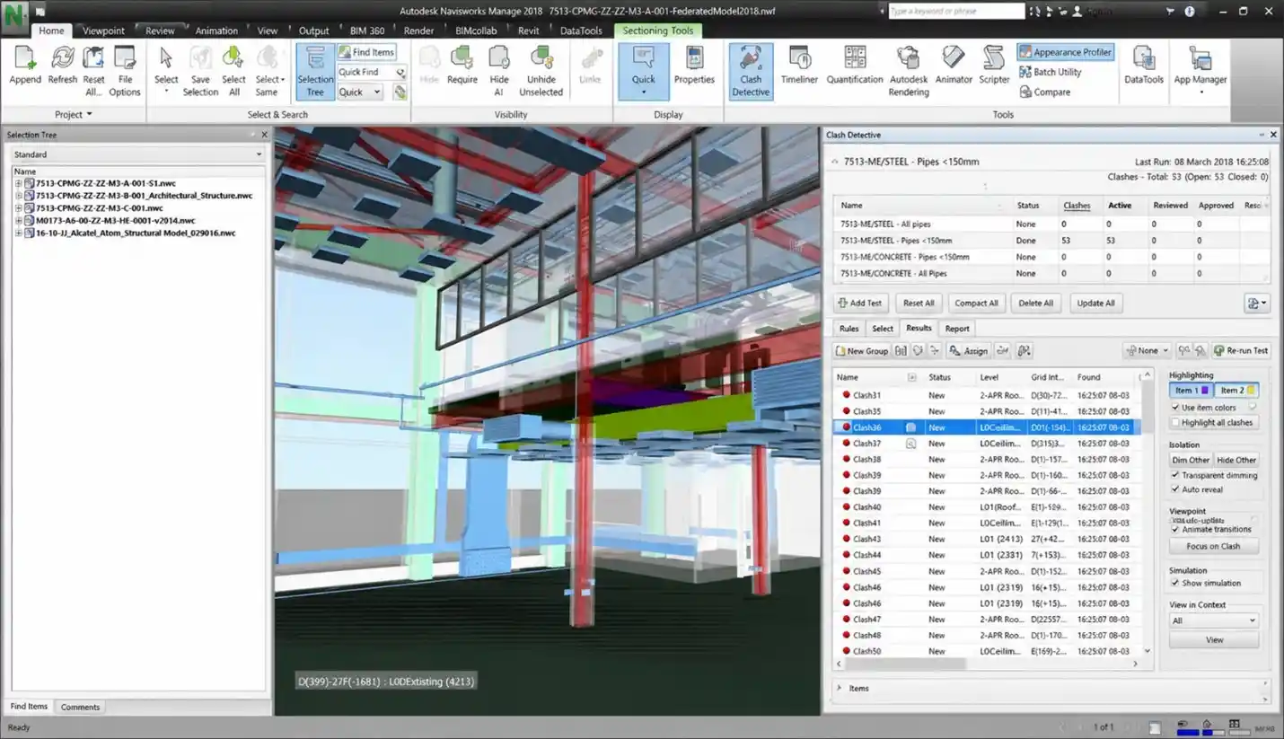
Federated BIM Model For BIM coordination and Clash Detection
Common Data Environment (CDE)
A CDE is a digital repository where project information, such as models, drawings, plans, and other associated documentation (e.g., RFIs, submittals, issue logs, etc.) can be stored, managed, and shared by authorized users of a project.
With BIM projects, it is no longer acceptable to send different versions of documents to different people on different teams. The project members should access the latest approved information for their task within the CDE.
A well-managed CDE helps organizations include:
- Improve collaboration across teams.
- Maintain version control.
- Reduce document duplication.
- Enhance traceability.
- Support approval workflows.
- Ensure data security.
- Improve project transparency.
4D BIM: Adding Time to the Model
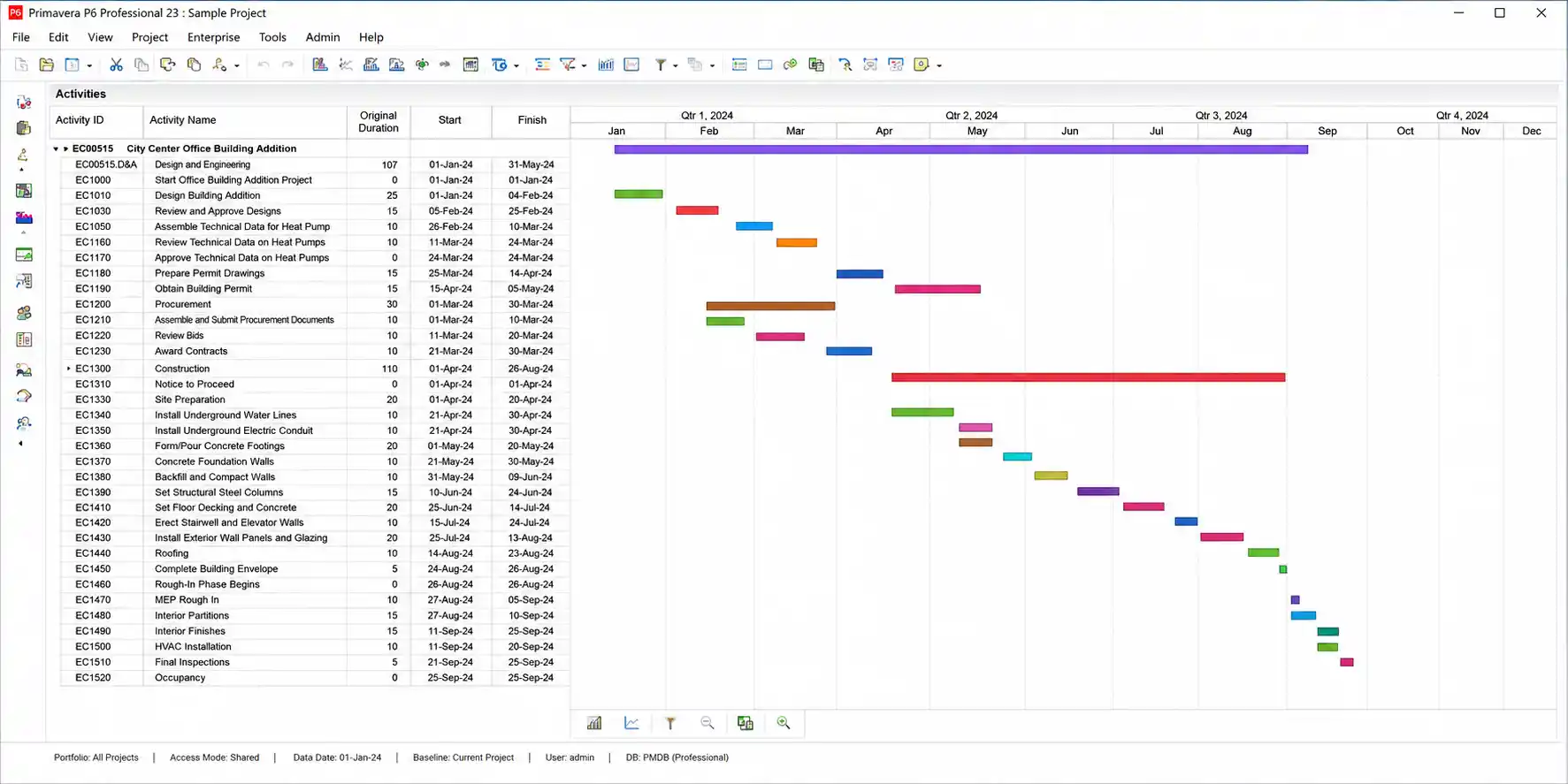
4D BIM brings the coordinated BIM model together with the project schedule to display the development of a project overtime. The fourth dimension is time.
Instead of viewing the construction of a project as a series of individual activities displayed within a project management tool such as MS Project, 4D BIM allows the user to see how a project will be constructed over time.
Benefits of 4D BIM
4D BIM advantages in construction project planning and execution.
Improved Construction Planning
To find the most efficient way of conducting a project by trying out different sequences of the construction of a project before the actual start of work.
Enhanced Site Logistics
Temporary facilities such as site offices, crane locations, storage areas, and access routes can be planned and perfected more effectively.
Better Stakeholder Communication
A 4D visualization of the construction process is far easier for others to understand than a Gantt chart. This is especially true for the owner, as well as the architect & engineer, and the contractor.
Reduced Delays
Potential scheduling problems can be detected early on and resolved in the best practical way.

4D BIM Simulation
5D BIM: Integrating Cost with Design
5D BIM automatically calculates the quantities for all the elements in the BIM model. Every element in the BIM model has quantitative information to measure the elements, such as length, surface, volume, or even count. The quantities of the elements can then be linked to a cost database to decide the costs for every single element.
The information generated within the 5D BIM model, about the quantities and the cost of information to complete the project, will automatically update as the design goes through the various phases of the construction of the project.
- 5D BIM reduces manual measurements, saving time and improving accuracy.
- Estimators quickly create project budgets, with updated quantities generated automatically from the evolving 3D BIM model.
- Monitor design changes with the team and assess their impact on project costs.
- Accurate ordering of materials minimizes waste and saves time.
- 5D simulation tool quickly checks construction cost and time for alternative designs.
Digital Twins: Extending BIM Beyond Construction
A BIM model used for design and the construction of a building is extended by a Digital Twin into the facility’s lifetime. Digital Twin is constantly receiving data from the building’s connected systems.
- IoT sensors
- Building Management Systems (BMS)
- Energy monitoring systems
- Occupancy sensors
- Security systems
- Maintenance management software
Information obtained by Digital Twin is used by the facility manager to check the building and its performance, to predict required maintenance, and to perfect building operations.
Applications for Digital Twins
As buildings and the managers who oversee them are managed as digital assets, the Digital Twins of these buildings will become a standard part of digital asset and facility management systems.
Digital Twins are increasingly used for:
- Predictive maintenance
- Asset lifecycle management
- Energy optimization
- Space use analysis
- Facility performance monitoring
- Emergency response planning
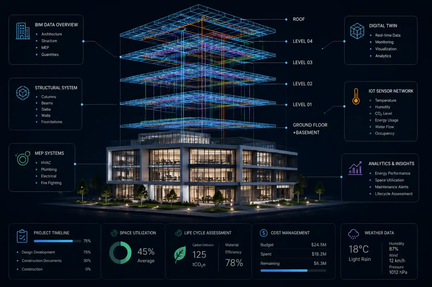
Digital Twins
Artificial Intelligence in Digital Construction
Artificial Intelligence (AI) already significantly enhances advanced construction workflows. Thus, on the one hand, it supports decision-making. On the other hand, there are also automated processes that, for structural reasons, are still characterized by an important level of complexity and thus are very time-consuming.
AI-powered tools can help with:
- Automated clash detection
- Model quality validation.
- Schedule optimization
- Risk prediction
- Quantity extraction
- Progress monitoring through computer vision
- Predictive analytics for project delivery
The Future of Advanced Construction Workflows
The future of construction will be about fully integrating the digital world of construction with the physical assets that are being created.
Innovative uses of AI and machine learning, construction with robots and autonomous equipment, the use of drones, cloud computing, and the use of Digital Twins of buildings and other assets to create intelligent construction and operational ecosystems.
Recent technologies like mixed reality, machine learning, generative design, and real-time sensor data will play a significant role in deciding the future of the built environment and the workflows to design and construct it.
Conclusion
The construction industry is moving away from traditional methods of project delivery and towards a more integrated, data-driven way of working with a range of technologies that interlink to form a digital construction strategy.
Accurate information about the current state of a site, an intelligent BIM model, effective BIM coordination of multiple disciplines, 4D scheduling, and 5D cost management support better decision-making throughout the entire asset lifecycle of a building. They also support improved collaboration, reduced project risks, and reduced rework.
The benefits of the advanced construction workflows can extend beyond the end of the construction project.
The information captured during the building process can be used to create a Digital Twin of the completed building. This Digital Twin can then be used in conjunction with real-time performance data from the building to allow for predictive maintenance of the building, best building performance, and effective asset management. Now is the ideal time to begin the digital journey of your organization using the advanced construction workflows to deliver more efficient, cost-effective, sustainable, and resilient assets.
Ready to move beyond 2D drawings? Explore Tesla Outsourcing Services’ Scan to BIM solutions for data-rich, end-to-end digital construction workflows.
Contact Us